API for GIS & ArcGIS
Our API can be easily integrated into ArcGIS, QGIS or other GIS systems. Our Grid API provides area data in a WebMapTileService (WMTS) and in other mapping formats.
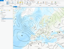
Example: Display of isobars as a WMTS in ArcGIS Pro.
Available Parameters (selection)
GridAPI
| cloudforecast | Cloud forecast for Europe |
| radarforecast | Precipitation forecast for the Alps |
| radar_hires | High resolution radar precipitation archive for Switzerland |
| cosmo1 | High resolution weather forecasts from Meteoswiss' COSMO-1 model covering the Alps | dozens of parameters available |
| cosmo_de | High resolution weather forecasts from the German weather service covering Germany, Switzerland and Austria | dozens of parameters available |
| icon_eu | Medium resolution weather forecasts from the German weather service covering Europe | dozens of parameters available |
| gfs | Global GFS weather forecasts | dozens of parameters available |
| gfs_ensembles | Global GFS ensemble weather forecasts | dozens of parameters available |
| airquality_hourly | Hourly air quality maps for Switzerland |
| airquality_annual | Annual air quality maps for Switzerland |
| rad_monthly | Monthly irradiation maps for Europe |
| satellite | A large variety of current and archived satellite imagery |
| wrf_himalaya | High resolution weather forecasts from our in-house WRF model covering the Himalayas | dozens of parameters available |
| et0 | Evapotranspiration for Switzerland |