Spatial Analysis
Geographic Information Systems
Spatial analysis from cadastres to geomonitoring
We are specialists for analyses, processing and visualisation of complex spatial data.
Thanks to our technical and professional competences we can cater to a broad range of target groups. Possible applications are:
- Emission cadastres
- Modelling of pollutant dispersion
- Solar cadastres (e.g. sonnendach.ch)
- Potential studies for renewable energies
- Management of geo-inventories
- Monitoring, time series
The necessary skills for data processing
We prepare the required data, combine point, line and shape data, assign the corresponding attributes, create the criteria for linking, intersecting and analyzing the data, and visualize the results in an intuitive form.
Grid and vector evaluations, geoprocessing, automation, dynamic segmentation, spatial interpolation as well as the inclusion of statistics and time series are part of our daily tasks.
In doing so, we always use the latest technical developments of ArcGIS.
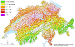
Particulate matter modeling (PM10) - Source: Swiss Federal Office for the Environment.
Cartography on Paper, Digital and Online
A large number of issues lead to a thematic map as a result. Depending on the requirements, we create simple field maps or high quality products for print, web, or as ArcGIS- and QGIS-Projects.
With our interactive maps it is possible to display spatial information on varying scales. We create lightweight Web GIS applications with rich content. Our map application MAAP allows the integration of data into a web application.
We design our maps with focus on optimal legibility, expressiveness and clarity.
Synergies with other business areas
Our competences in geoinformatics serve to support many of the projects in our other business fields.
By combining our GIS competences with our expertise the areas of air quality, weather forecasting, climatology or the energy industry (wind energy and solar energy), we can add value to your data. Thanks to our know-how in the field of web & software we are able to deliver the results online in an intuitive and efficient manner.