GeoAI
Artificial Intelligence object detection makes more out of aerial imagery.
Geospatial Artificial Intelligence (GeoAI) is the integration of Artificial Intelligence (AI) with geospatial data. Meteotest has developed a workflow in the field of object recognition and analysis from remote sensing data (aerial, drone and satellite imagery):
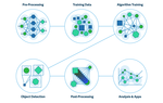
AI Object Detection Workflow
Our AI workflow for object detection consists of the following steps:
- Pre-processing: The required data sets such as aerial photographs, 3D building data or road geometries are evaluated and prepared.
- Training Data: Meteotest generates the data required for training and validation of the AI algorithm.
- Algorithm Training: Our partner Picterra uses the training dataset to train the algorithm (Deep Learning).
- Object Detection: Object recognition is run on the corresponding platform of Picterra.
- Post-processing: Meteotest validates the recognition results and prepares them for further applications.
- Analysis & Apps: Meteotest combines the results with other data sets to create specific analyses or a customer app, depending on the application.
For example PV detection
As an example, you want to create an inventory of photovoltaic systems on rooftops. In the first step, the GIS specialist prepares the training data in ArcGIS - consisting of high-resolution aerial images and 3D building models (for identifying rooftops and including additional data such as orientation and inclination). To create the training data set, each PV system in the training area is marked manually.
The data scientist uses the training data set to train the AI algorithm. The model is iteratively calibrated and validated between GIS Specialist and Data Scientist until it provides the best possible recognition accuracy. Subsequently, Object Detection is carried out for the whole target area. The result is be enriched with additional data in ArcGIS and integrated into a GIS webapp. This allows to visualize the data, to import further own datasets, to carry out analyses and to export results eg. for a marketing campaigns or planning purposes.

Partnership with Picterra
A strategic partnership between Meteotest and Picterra forms the core of our AI workflow. Since 2016, Picterra has specialized in object recognition from aerial and satellite imagery through the use of Artificial Intelligence. In our AI workflow, Picterra trains the Deep Learning algorithms and performs Object Detection.
Esri & Location Intelligence
We have been relying on the ArcGIS product range for more than 20 years. Esri has complemented its product line with specific interfaces to Machine Learning frameworks such as TensorFlow or Pytorch, as well as advanced IT technologies such as AWS, Docker and more. Read the e-book "Putting Location Intelligence to Work" at esri.com/ai.

Ask our expert:
Lukas Meyer
Project Manager Energy & Climate
| |