1/14/2020
NIR calculations with NISMap
NISMap is a software for the calculation of the immissions of high-frequency non-ionizing radiation (NIR). NISMap was developed and distributed by ARIAS. From 2020, the further development and support of NISMap will be carried out entirely by Meteotest.
The software NISMap was developed and distributed by the company ARIAS from 2001 to 2019. As part of a succession plan, the NISMap software and the underlying know-how were completely handed over to Meteotest between 2015 and 2019. From 2020 Meteotest will be fully responsible for the further development, sales and customer support of the NISMap software. This ensures that the software can continue to be updated and innovated as part of the development of Switzerland's mobile communications landscape.
The website has also been completely revised as part of the succession plan: www.nismap.ch
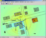
The basic version of NISMap is used for the calculation of immission forecasts and the creation of location data sheets. It is used by authorities as an execution guideline:
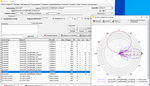
- NISMap calculates the electric field strength and the immission for different transmitters.
- NISMap manages the data of systems (antennas, buildings, locations, etc.) in a database.
- NISMap shows the results interactively on the map.
- NISMap produces field strength or immission maps and location data sheets formatted as Word documents in accordance with the FOEN specifications.
In addition to the basic version, there is also an extended version of NISMap. The extended version offers additional dispersion algorithms and options for calculating exposure maps for larger areas. NISMap can also be used to model immissions for a larger area, for example an entire city (NIR cadastre).
Version 6.0 of NISMap was released at the end of 2019. The following innovations are included in this version:
- NISMap now calculates field strength and immissions in the same calculation run and can switch the display between the two sizes.
- NISMap implements the compatibility of the new 5G frequency bands and radio services with OFCOM-DB.
- NISMap imports buildings in CityGML format (incl. Pitched roofs).
An overview of all new features can be found here.